
Donde Estan App
As an engineering student, I worked in my family’s small school bus company until I graduated. Over time, I visualized different needs that parents of children transported on school buses might have. As a result of these needs, Donde Estan App was born.
Donde Estan App
● Necesity
The school transportation service in the city of Santa Fe and surroundings arises from late 1970s and early 1980s, where it has been growing year after year along with the increase in school attendance at the initial, primary and secondary levels, and It has also generated a progressive increase in the demand for the service of School transportation. Parents of children transported in vans schoolchildren do not have control of the vehicle or the child once it is withdrawn from the home and transferred to the school establishment, and vice versa. In addition, different events can also occur that can cause delays in it, such as heavy traffic, rain, streets waterlogged or in poor condition, mechanical failure, tire breakage, among others. When such events occur, concerned parents begin to call and send messages to the driver, consulting his location and the cause caused this delay. At times when these events occur, the driver is focused on fixing the issue as quickly as possible and may may not be able to answer all the important queries parents have. These inconveniences influence a loss of time in the route, which may result in further delays in finding or returning each child to the address, or a delay in entering or leaving a school.
Due to this problem, it is intended to make a mobile application that visualize the geolocation of school vehicles and report, through a message automatically, in the status bar of your cell phone, the moment in which the transport arrives at the school or at the private address. East application work has two types of users, on the one hand, the “users observers” who are the parents or guardians of the children and, on the other hand, the “observed users” who are the drivers of school vehicles. Also The application allows the creation of warning messages to notify, in a way mass to all observer users, about events that may occur in the dynamics of a school transport route and there is a channel of communication between the observed user and the observing users, which allows the sending and receiving of instant messaging between said users.
● Goals
● General:
○ Develop a mobile application that allows viewing the geolocation of school transport and send notifications between observed users and observers.
● Specific:
○ Design and develop the mobile application from the part of the “observed users”. ○ Design and develop the mobile application from the part of the “observer users”. ○ Develop the web service for processing the information between Android app and web server (database). ○ Develop a method for displaying the geolocation of school vehicles, in order to obtain and show your location in real time. ○ Develop a method to integrate shipping and viewing of automatic and massive notifications, in order to communicate.
● Development
- An analysis of requirements and techniques to be used for the development of the project, as well as a study on the different technologies to be used, such as the programming language JAVA, Android SDK, GPS functionality, Web Service and server Push Notifications.
- The tools were selected and the design of the tools was carried out. class diagrams, database structure, how they will interact the different parts of the project and the presentation of the graphical interface through mockups.
- The development of the database and the web service was carried out, the which is responsible for exchanging information between the Android application and the database. In addition, they spread both developments in AWS services (RDS and Elastic Beanstalk).
- The functionalities and the graphical interface of the application were developed mobile.
- The connection of the mobile application to the services was made deployed on AWS.
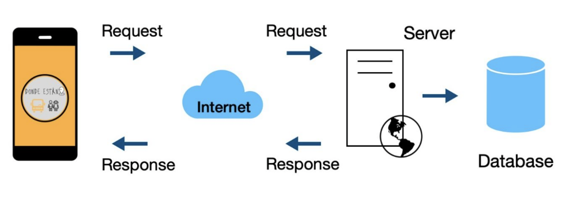
Architecture
● Results - Conclusions
• As a result of this work, a mobile application was obtained Android that allows the visualization of the geolocation of school vehicles and the sending of information in real time between users through messaging and automatic notifications and massive.
• It was possible to visualize the geolocation of the driver on a map, as well as also the sending of automatic arrival notifications and bulk overview notifications. In addition, it generated a new communication channel through instant messaging between users.
• At the same time, and exceeding the proposed objectives, it was possible make the web service available on AWS.
• In the long term, this project could incorporate new languages, make the application compatible with iOS devices, incorporate authentication mechanisms via email and allow the registration of more of a driver.